*Dave’s Version
[See this mapped: A3-2024, Dave’s Vision]
About: Understand this SO-RCD 💾 doc
S1-1984 contains scans and transcripts of the 1st edition of Saltwater People, a foundational text of W̱SÁNEĆ Saanich cultural knowledge from the transcribed lectures of PENÁĆ Dave Elliott Sr. In its 1990 2nd edition, Saltwater People is widely available online and at libraries, especially on and around Vancouver Island, and the Gulf and San Juan Islands. Rights-holder W̱SÁNEĆ Leadership Council shares this PDF, a scan from Belinda Claxton’s copy.
As I began my research into SENĆOŦEN Saanich-language place names, it became clear that the 2nd edition was influential on subsequent publicly available maps and lists of names. I was unable to track down any copies of the 1st edition, and found no references to it in the secondary material I reviewed.
On December 15, 2023, I visited the UVic libraries for the first time. Before lunch, I had unexpectedly come by the text reproduced in part below: a 1st edition of Salt Water People. After comparing it to the 2nd edition, I identified these pages as having significantly changed by the 1990 printing, and share them below in hopes that they might bridge some gaps.
The transcripts below reproduce any typographical errors from the original. Place names have been restructured into tables. Assuming cultural property to be represented by W̱SÁNEĆ, who have made the 2nd edition freely available as an educational resource, Factso hosts this version under fair use for similar open-access reasons.
Inside: What this SO-RCD 💾 doc tells us
Why call this “Dave’s Version?” Both editions provide Dave an author’s credit, but the 1st edition — with its distinctively bold fonts and modern design — appears to be much closer to the original transcripts, as I realized when comparing place name lists.
Timothy Montler’s 2018 electronic dictionary draws from here directly, accounting for some of the discrepancies with later sources. Per the preamble to the index of place names in the 2nd edition, the list was revised from the original and reviewed by YELḰATṮE Earl Claxton Sr., Dave’s nephew, who continued his work alongside Dave’s kids John and Linda.
As noted in its acknowledgments, the text in the 1st edition was “transcribed and typed [from] hours of taped lectures and interviews” by Diana Henry, who also “typed the final manuscript.” Henry’s typesetting was therefore likely a lot closer to the actual things Dave said — and her fonds must be freakin’ incredible.
Epigraphy: comparing different versions of the same text and asking why the differences are there. Confused at some of the divergences between Montler’s list of place names and the locations given in Earl’s Version, I have found some answers in Dave’s Version… and many new questions.
I will follow up with my insights in a separate post. In the meantime, enjoy your exploration of this rare edition of Saltwater People. Dave’s Version: 30,000 years’ knowledge, delicately handled by a classroom of Sidney teenagers 40 years ago, printed for the first time in June 1984 (school year 1983, as the copyright notes).
Contents: Navigate this SO-RCD 💾 doc
Scans: Salt Water People, 1st edition, June 1984; Covers, pages 1 to 4, 64 to 69
Transcripts follow. Images link to texts; texts link to images.
Transcript: PENÁĆ Dave Elliott’s SENĆOŦEN Alphabet & Place Names in Saanich Territory
Front Cover – Table of Contents
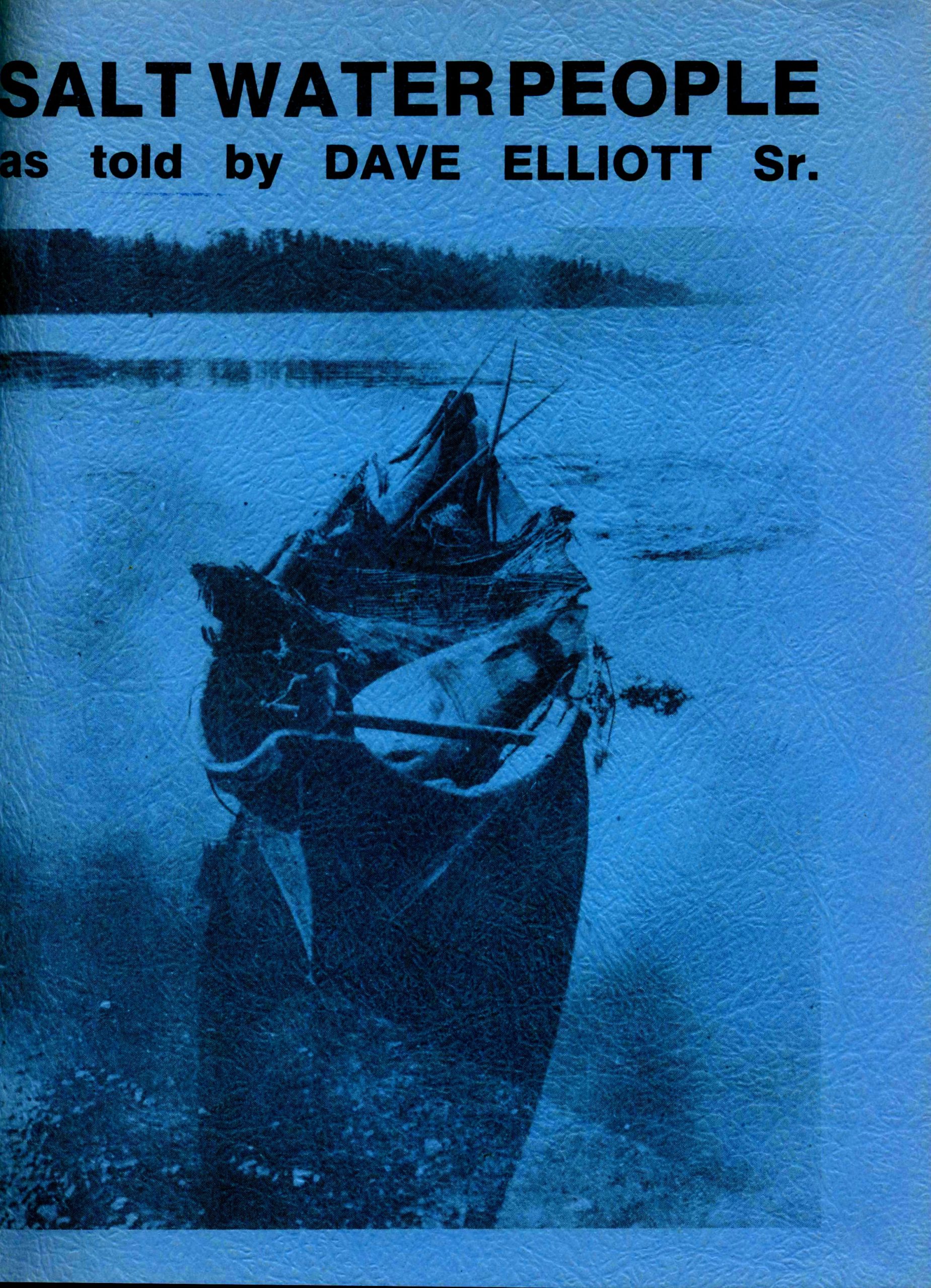
SALT WATER PEOPLE
as told by DAVE ELLIOTT SR.
COVER PHOTO: Saanich Canoe photographed in 1923 at Tsawout (East Saanich Reserve). The large float at the front of the canoe is probably made from a seal skin. It would be attached to a harpoon line to keep the harpooned animal from sinking. There are two harpoon shafts at the back of the canoe. The rush mat was sat upon or it could be attached to the large pole along the left side of the canoe and used as a sail.
B.C. Provincial Museum
Inside Front Cover
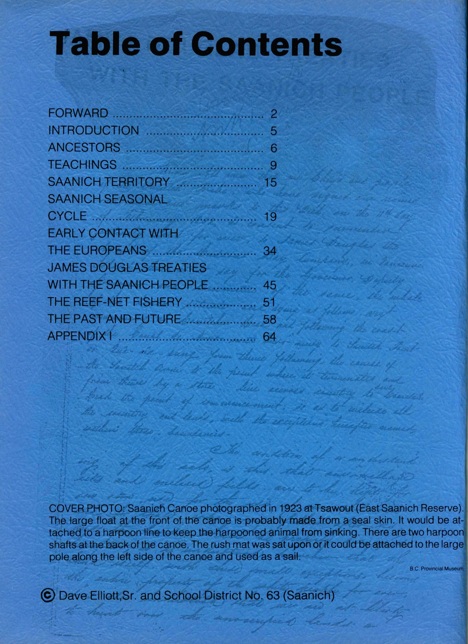
Table of Contents
| FORWARD | 2 |
| INTRODUCTION | 5 |
| ANCESTORS | 6 |
| TEACHINGS | 9 |
| SAANICH TERRITORY | 15 |
| SAANICH SEASONAL CYCLE | 19 |
| EARLY CONTACT WITH THE EUROPEANS | 34 |
| JAMES DOUGLAS TREATIES WITH THE SAANICH PEOPLE | 45 |
| THE REEF-NET FISHERY | 51 |
| THE PAST AND FUTURE | 58 |
| APPENDIX I | 64 |
© Dave Elliott, Sr. and School District No. 63 (Saanich)
[Bulk of book content excluded, as middle chapters are consistent with 2nd ed.]
Page 1
[Signature, blue ink, centre to top right; reads Dave Elliott.]
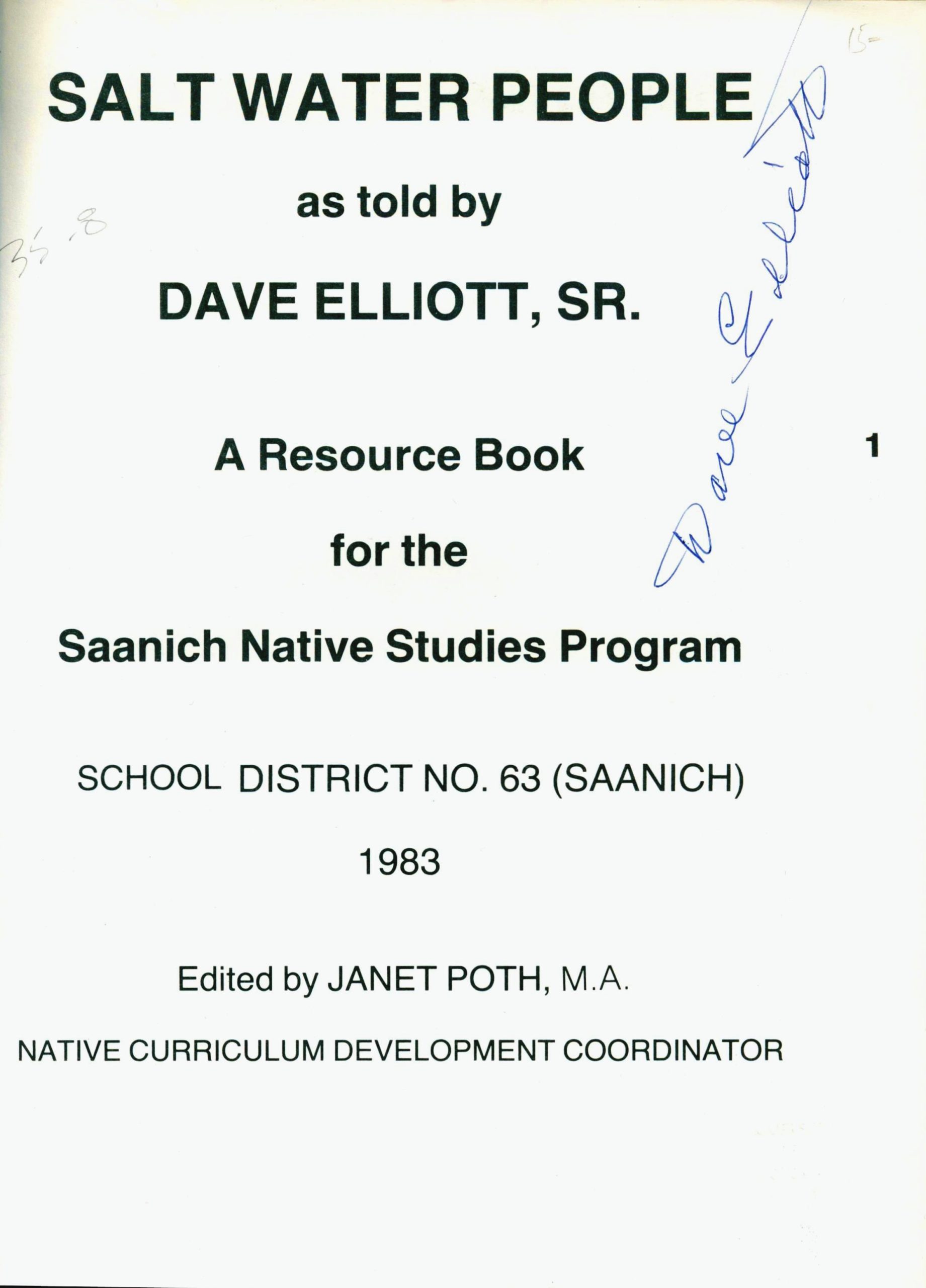
SALT WATER PEOPLE
as told by
DAVE ELLIOTT, SR.
A Resource Book
for the
Saanich Native Studies Program
SCHOOL DISTRICT NO. 63 (SAANICH)
1983
Edited by JANET POTH, M.A.
NATIVE CURRICULUM DEVELOPMENT COORDINATOR
[Pricing from book sales in pencil: top right, 15–; near top left, 3500.]
Page 2
[Library access codes in pencil: top right, M45529A, LAB238; under heading, Law, KID40, E55, 1983. Original in University of Victoria Archives.]
FORWARD
Dave Elliott has said, “I grew up with one foot in each century.” Because of this Dave has recounted the history of his People, and the history of the settlers, as neither has been told before. I have seen people sit entranced for hours listening to his accounts of our entwined history.
During the last seven years at Stelly’s School hundreds of students have had the priviledge of hearing Dave Elliott speak on the topics covered in the book. It is intended as a resource book for use with grade nine, ten and eleven courses of the Saanich Native Studies Program in School District 63 (Saanich). As such, the topics are limited and by no means represent the wealth of historical and cultural information from the life and experiences of Dave Elliot.
These are Dave’s words and thoughts. It is the product of hours of tape edited for the written word.
The writing system for the Saanich dialect used in this book was developed and taught to me by Dave Elliott.
Over the seven years of working with Dave I have been most inspired by his concern for his People and for the future of us all.
Janet Poth
Native Curriculum Development Coordinator
June 1984
Page 3
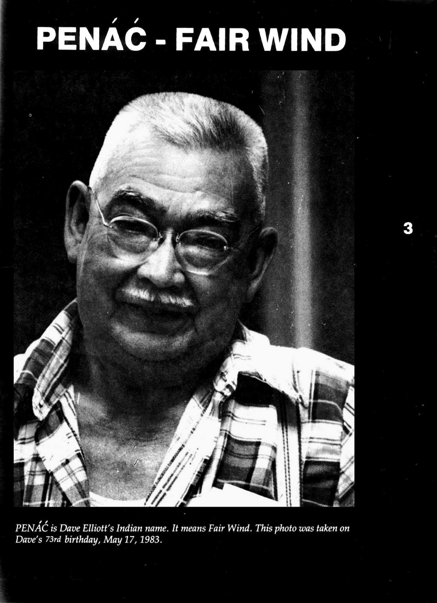
PENÁĆ – FAIR WIND
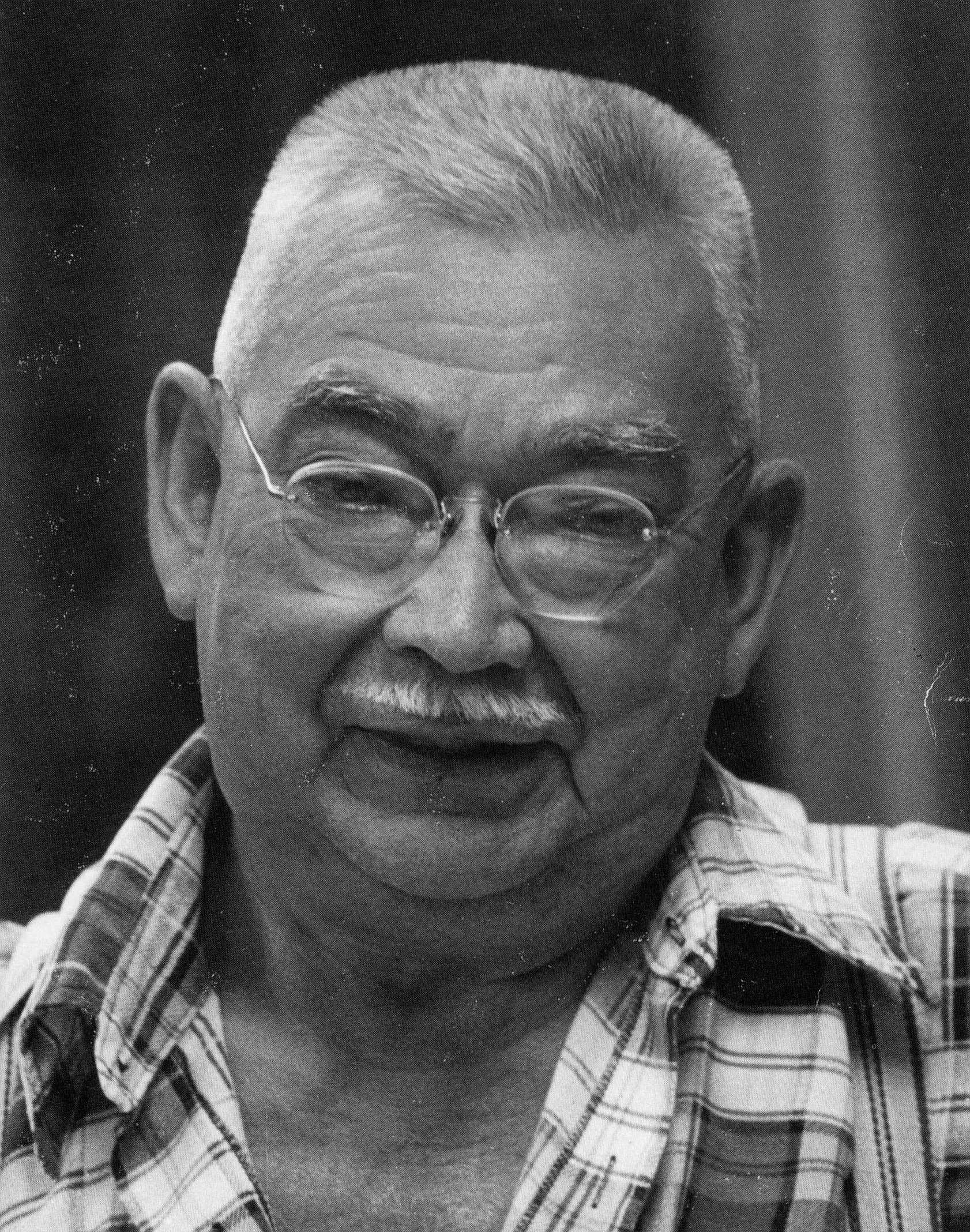
PENÁĆ is Dave Elliott’s SENĆOŦEN name. It means Fair Wind. This photo was taken on Dave’s 73rd birthday, May 17, 1983.
Page 4
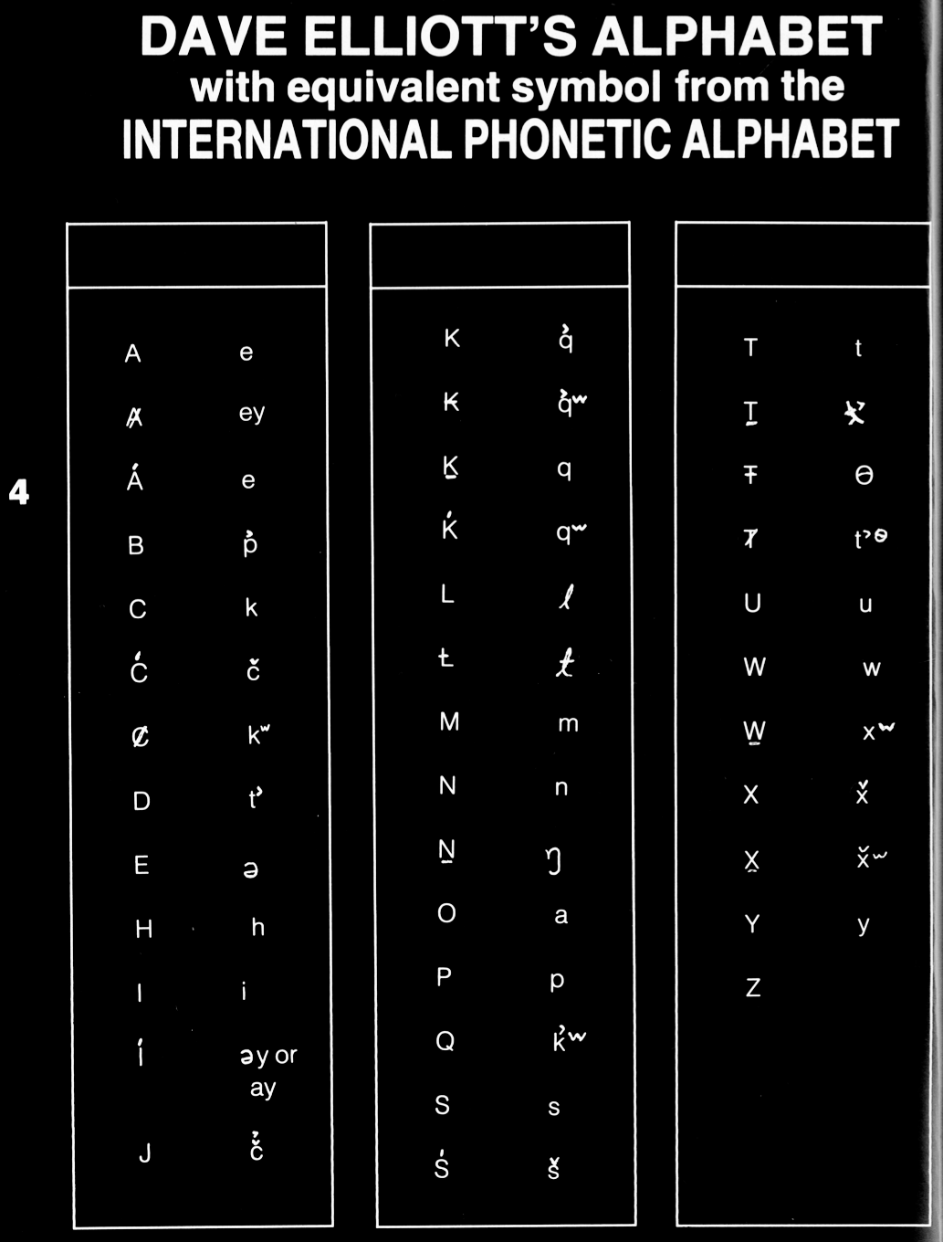
DAVE ELLIOTT’S ALPHABET
with equivalent symbol from the
INTERNATIONAL PHONETIC ALPHABET
[Editor’s note: Symbols are drawn from Americanist linguistic phonetics, distinct from IPA. Where divergent, IPA added [in yellow]. Table last updated 250301.]
A | e |
Ⱥ | ey [ej] |
Á | e [ee] |
B | p̓ |
C | k |
Ć | č [ʧ] |
Ȼ | kʷ |
D | t̓ |
E | ə |
H | h |
I | i |
Í | əy [əj] or ay [aj] |
J | č̓ [ʧ̓] |
K | q̓ |
₭ | q̓ʷ |
Ḵ | q |
Ḱ | qʷ |
L | l |
Ƚ | ɬ |
M | m |
N | n |
Ṉ | ŋ |
O | a |
P | p |
Q | k̓ʷ |
S | s |
Ś | š [ʃ] |
T | t |
Ṯ | ƛ̓ [tɬʼ] |
Ŧ | θ |
Ⱦ | t̓ᶱ |
U | u |
W | w |
W̱ | xʷ |
X | x̌̌ [χ] |
X̱ | x̌̌ʷ [χʷ] |
Y | y [j] |
Z | |
| , | ʔ |
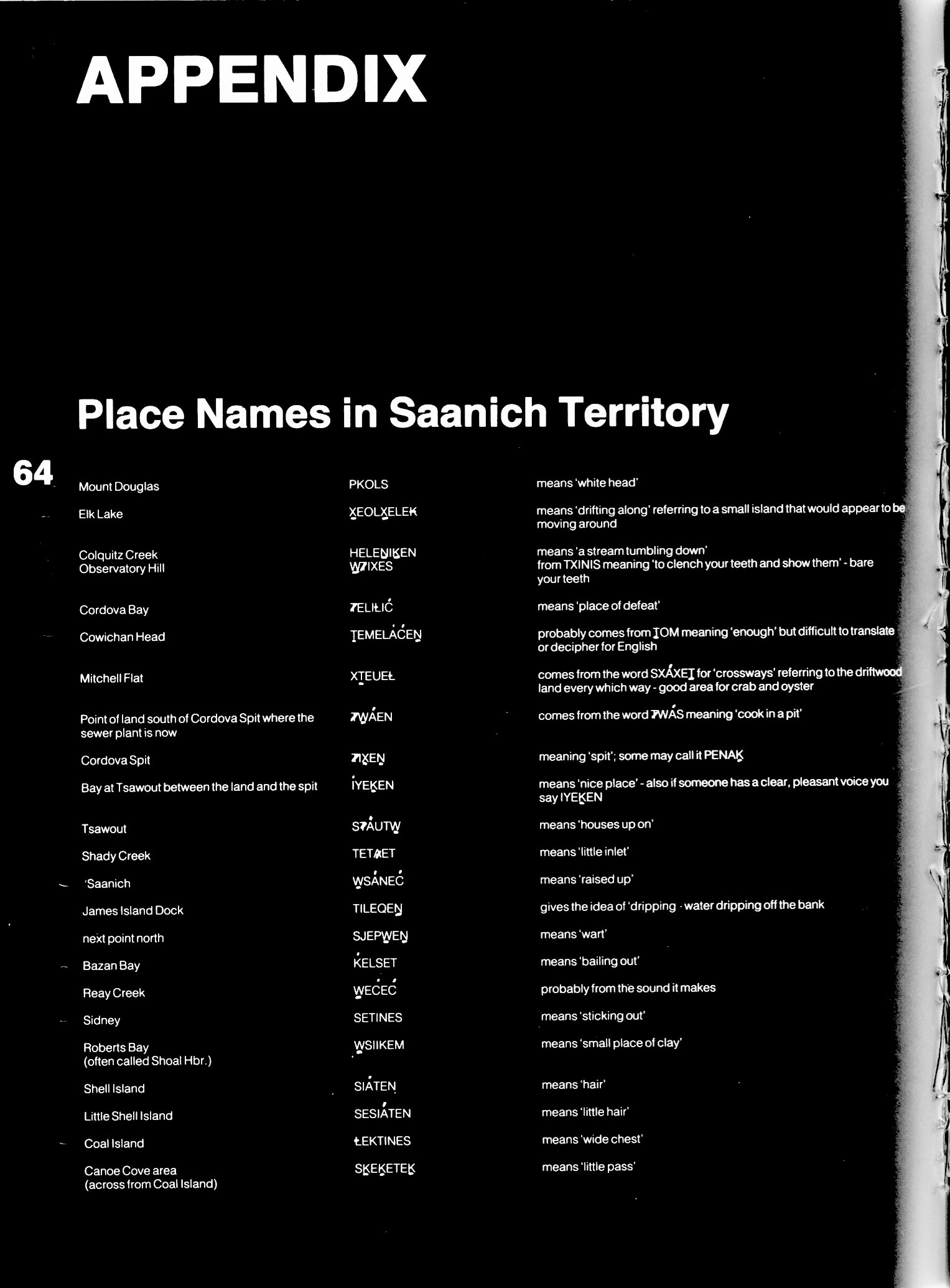
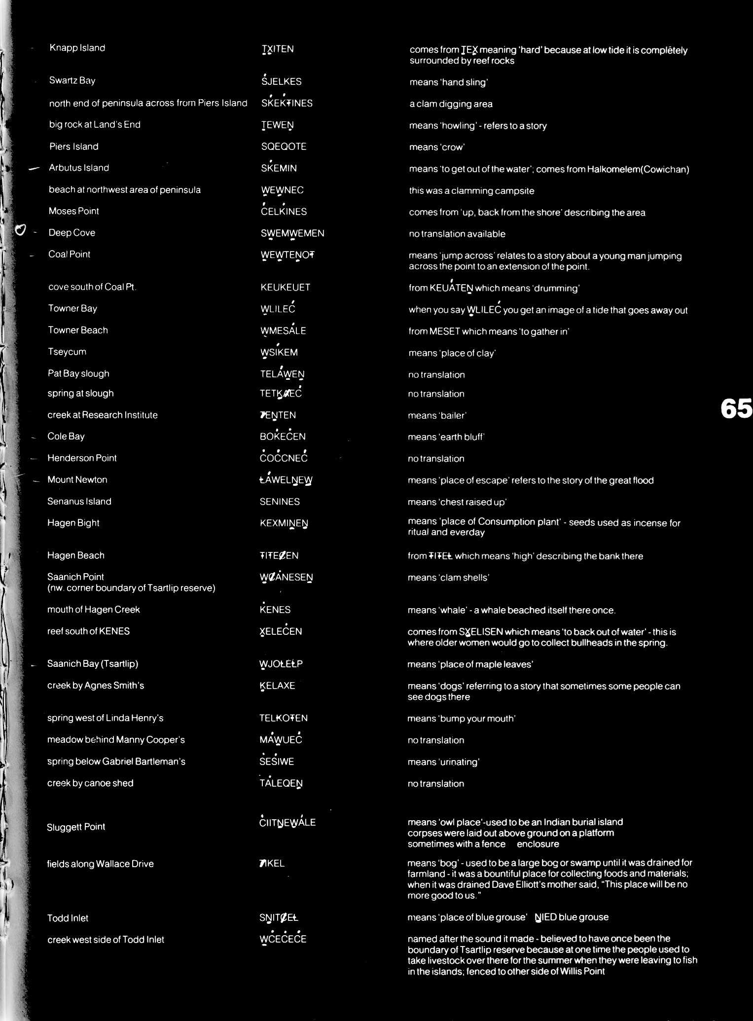
Page 64
[Content from pages 5-63 similar in the 1990 2nd edition.]
APPENDIX
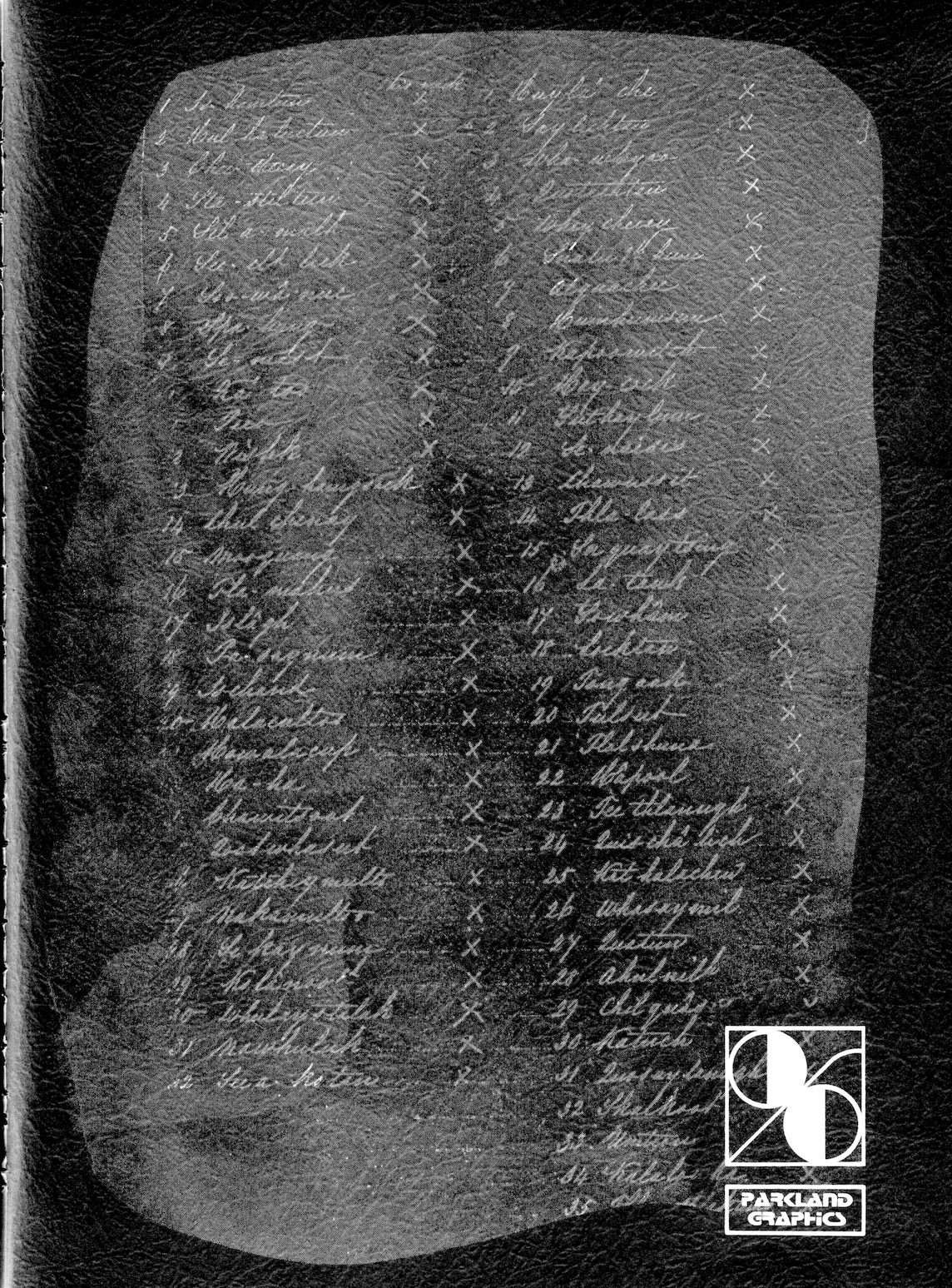
Place Names in Saanich Territory
| # | Name | PENÁĆ Says |
|---|---|---|
| 1 | PKOLSMount Douglas | means ‘white head’ |
| 2 | X̱EOLX̱ELE₭Elk Lake | means ‘drifting along’ referring to a small island that would appear to be moving around |
| 3 | HELEṈIḴENColquitz Creek | means ‘a stream tumbling down’ |
| 4 | W̱ȾIXESObservatory Hill | from TXINIS meaning ‘to clench your teeth and show them’ – bare your teeth |
| 5 | ȾELIȽIĆCordova Bay | means ‘place of defeat’ |
| 6 | ṮEMELÁĆEṈCowichan Head | probably comes from ṮOM meaning ‘enough’ but difficult to translate or decipher for English |
| 7 | XṮEUEȽMitchell Flat | comes from the word SXÁXEṮ for ‘crossways’ referring to the driftwood land every which way – good area for crab and oyster |
| 8 | ȾW̱ÁENPoint of land south of Cordova Spit where the sewer plant is now | comes from the word ȾWÁS meaning ‘cook in a pit’ |
| 9, 10 | ȾIX̱EṈ • PENAḴCordova Spit | meaning ‘spit’; some may call it PENAḴ |
| 11 | ÍYEḴENBay at Tsawout between the land and the spit | means ‘nice place’ – also if someone has a clear, pleasant voice you say IYEḴEN |
| 12 | SȾÁUTW̱Tsawout | means ‘houses up on’ |
| 13 | TETȺETShady Creek | means ‘little inlet’ |
| 14 | W̱SÁNEĆ‘Saanich | means ‘raised up’ |
| 15 | TILEQEṈJames Island Dock | gives the idea of ‘dripping – water dripping off the bank |
| 16 | SJEPW̱EṈnext point north | means ‘wart’ |
| 17 | ḰELSETBazan Bay | means ‘bailing out’ |
| 18 | W̱EĆEĆReay Creek | probably from the sound it makes |
| 19 | SETINESSidney | means ‘sticking out’ |
| 20 | W̱SIIKEMRoberts Bay (often called Shoal Hbr.) | means ‘small place of clay’ |
| 21 | SIÁTENShell Island | means ‘hair’ |
| 22 | SESIÁTENLittle Shell Island | means ‘little hair’ |
| 23 | ȽEKTINESCoal Island | means ‘wide chest’ |
| 24 | SḴEḴETEḴCanoe Cove area (across from Coal Island) | means ‘little pass’ |
Page 65
| # | Name | PENÁĆ Says |
|---|---|---|
| 25 | ṮX̱ITENKnapp Island | comes from ṮEX̱ meaning ‘hard’ because at low tide it is completely surrounded by reef rocks |
| 26 | ŚJELKESSwartz Bay | means ‘hand sling’ |
| 27 | SḰEḰŦINESnorth end of peninsula across from Piers Island | a clam digging area |
| 28 | ṮEWEṈbig rock at Land’s End | means ‘howling’ – refers to a story |
| 29 | SQEQOTEPiers Island | means ‘crow’ |
| 30 | SḰEMINArbutus Island | means ‘to get out of the water’; comes from Halkomelem (Cowichan) |
| 31 | W̱EW̱NEĆbeach at northwest area of peninsula | this was a clamming campsite |
| 32 | ĆELḰINESMoses Point | comes from ‘up, back from the shore’ describing the area |
| 33 | SW̱EMW̱EMENDeep Cove | no translation available |
| 34 | W̱EW̱TEṈOŦCoal Point | means ‘jump across’ relates to a story about a young man jumping across the point to an extension of the point. |
| 35 | KEUKEUETcove south of Coal Pt. | from KEUÁTEṈ which means ‘drumming’ |
| 36 | W̱LILEĆTowner Bay | when you say W̱LILEĆ you get an image of a tide that goes away out |
| 37 | W̱MESÁLETowner Beach | from MESET which means ‘to gather in’ |
| 38 | W̱SÍKEMTseycum | means ‘place of clay’ |
| 39 | TELÁW̱EṈPat Bay slough | no translation |
| 40 | TETḴȺEĆspring at slough | no translation |
| 41 | ȾEṈTENcreek at Research Institute | means ‘bailer’ |
| 42 | BOḰEĆENCole Bay | means ‘earth bluff’ |
| 43 | ĆOĆCNEĆHenderson Point | no translation |
| 44 | ȽÁWELṈEW̱Mount Newton | means ‘place of escape’ refers to the story of the great flood |
| 45 | SENINESSenanus Island | means ‘chest raised up’ |
| 46 | KEXMIṈEṈHagen Bight | means ‘place of Consumption plant’ – seeds used as incense for ritual and everday |
| 47 | ŦIŦEȻENHagen Beach | from ŦIŦEȽ which means ‘high’ describing the bank there |
| 48 | W̱ȻÁNESEṈSaanich Point (nw. corner boundary of Tsartlip reserve) | means ‘clam shells’ |
| 49 | ḰENESmouth of Hagen Creek | means ‘whale’ – a whale beached itself there once. |
| 50 | X̱ELEĆENreef south of KENES | comes from SX̱ELISEN which means ‘to back out of water’ – this is where older women would go to collect bullheads in the spring. |
| 51 | W̱JOȽEȽPSaanich Bay (Tsartlip) | means ‘place of maple leaves’ |
| 52 | ḴELAXEcreek by Agnes Smith’s | means ‘dogs’ referring to a story that sometimes some people can see dogs there |
| 53 | TEL₭OŦENspring west of Linda Henry’s | means ‘bump your mouth’ |
| 54 | MÁW̱UEĆmeadow behind Manny Cooper’s | no translation |
| 55 | ŚEŚIWEspring behind Gabriel Bartleman’s | means ‘urinating’ |
| 56 | TÁLEQEṈcreek by canoe shed | no translation |
| 57 | ĆIITṈEW̱ÁLESluggett Point | means ‘owl place’ – used to be an Indian burial island • corpses were laid out above ground on a platform sometimes with a fence • enclosure |
| 58 | ȾIKELfields along Wallace Drive | means ‘bog’ – used to be a large bog or swamp until it was drained for farmland – it was a bountiful place for collecting foods and materials; when it was drained Dave Elliott’s mother said, “This place will be no more good to us.” |
| 59 | SṈITȻEȽTodd Inlet | means ‘place of blue grouse’ • ṈIED blue grouse |
| 60 | W̱ĆEĆEĆEcreek west side of Todd Inlet | named after the sound it made – believed to have once been the boundary of Tsartlip reserve because at one time the people used to take livestock over there for the summer when they were leaving to fish in the islands; fenced to other side of Willis Point |
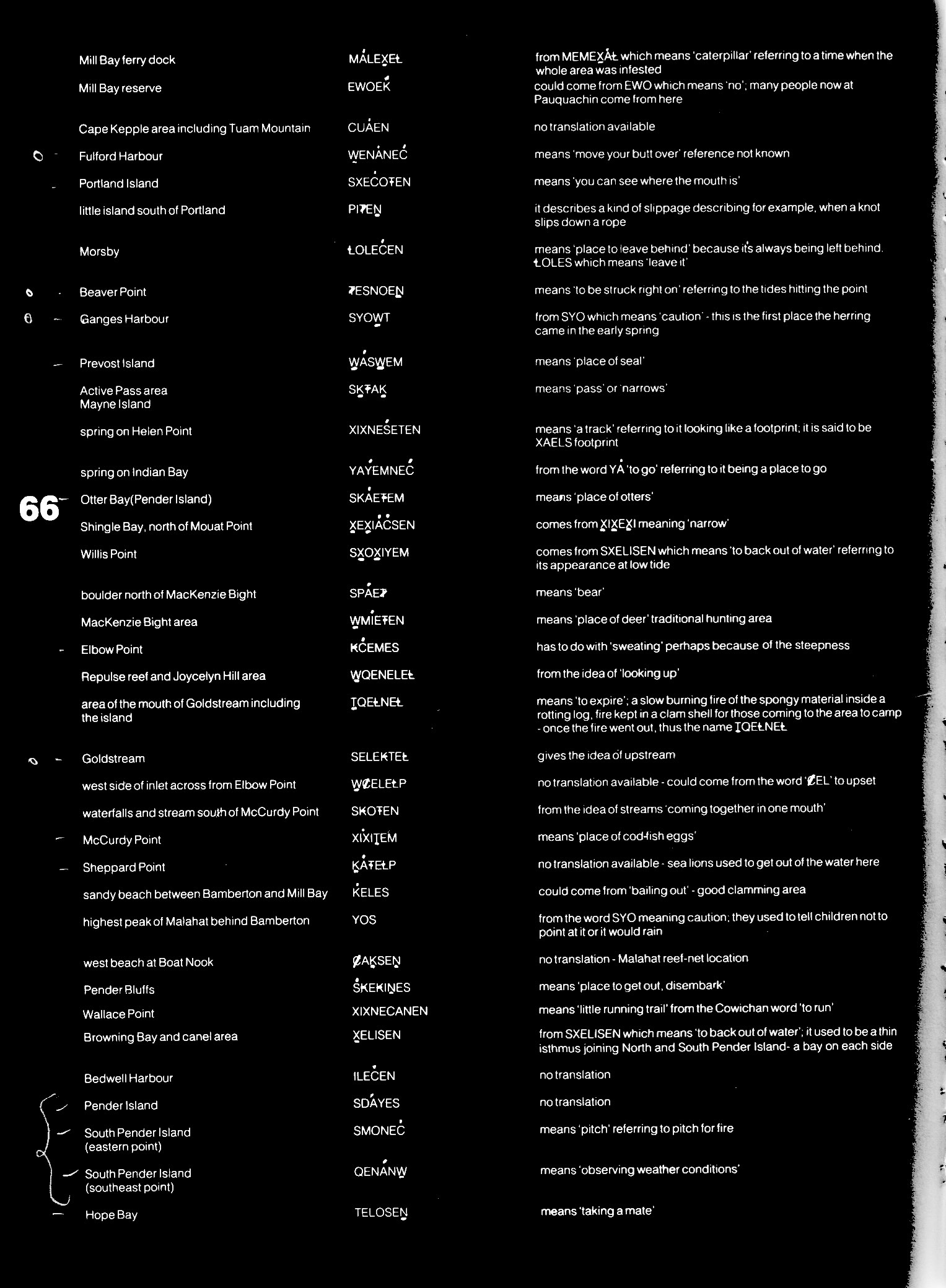
Page 66
| # | Name | PENÁĆ Says |
|---|---|---|
| 61 | MÁLEX̱EȽMill Bay ferry dock | from MEMEX̱ÁȽ which means ‘caterpillar’ referring to a time when the whole area was infested |
| 62 | EWOEḰMill Bay reserve | could come from EWO which means ‘no’; many people now at Pauquachin come from here |
| 63 | CUÁENCape Kepple area including Tuam Mountain | no translation available |
| 64 | W̱ENÁNEĆFulford Harbour | means ‘move your butt over’ • reference not known |
| 65 | SXEĆOŦENPortland Island | means ‘you can see where the mouth is’ |
| 66 | PIȾEṈlittle island south of Portland | it describes a kind of slippage describing for example when a knot slips down a rope |
| 67 | ȽOLEĆENMorsby | means ‘place to leave behind’ because it’s always being left behind. ȽOLES which means ‘leave it’ |
| 68 | ȾESNOEṈBeaver Point | means ‘to be struck right on’ referring to the tides hitting the point |
| 69 | SYOW̱TGanges Harbour | from SYO which means ‘caution’ – this is the first place the herring came in the early spring |
| 70 | W̱ÁSW̱EMPrevost Island | means ‘place of seal’ |
| 71 | SḴŦAḴActive Pass area • Mayne Island | means ‘pass’ or ‘narrows’ |
| 72 | XIXNEŚETENspring on Helen Point | means ‘a track’ referring to it looking like a footprint; it is said to be XAELS footprint |
| 73 | YÁYEMNEĆspring on Indian Bay | from the word YÁ ‘to go’ referring to it being a place to go |
| 74 | SKÁEŦEMOtter Bay (Pender Island) | means ‘place of otters’ |
| 75 | X̱EX̱IÁĆSENShingle Bay, north of Mouat Point | comes from X̱IX̱EX̱I meaning ‘narrow’ |
| 76 | SX̱OX̱IYEMWillis Point | comes from SXELISEN which means ‘to back out of water’ referring to its appearance at low tide |
| 77 | SPÁEȾboulder north of MacKenzie Bight | means ‘bear’ |
| 78 | W̱MÍEŦENMacKenzie Bight area | means ‘place of deer’ traditional hunting area |
| 79 | ₭ĆEMESElbow Point | has to do with ‘sweating’ perhaps because of the steepness |
| 80 | W̱QENELEȽRepulse reef and Joycelyn Hill area | from the idea of ‘looking up’ |
| 81 | ṮQEȽNEȽarea of the mouth of Goldstream including the island | means ‘to expire’; a slow burning fire of the spongy material inside a rotting log, fire kept in a clam shell for those coming to the area to camp – once the fire went out, thus the name ṮQEȽNEȽ |
| 82 | SELE₭TEȽGoldstream | gives the idea of upstream |
| 83 | W̱ȻELEȽPwest side of inlet across from Elbow Point | no translation available – could come from the word ‘ȻEL‘ to upset |
| 84 | S₭OŦENwaterfalls and stream south of McCurdy Point | from the idea of streams ‘coming together in one mouth’ |
| 85 | XÍXIṮEMMcCurdy Point | means ‘place of cod-fish eggs’ |
| 86 | ḴÁŦEȽPSheppard Point | no translation available – sea lions used to get out of the water here |
| 87 | ḰELESsandy beach between Bamberton and Mill Bay | could come from ‘bailing out’ – good clamming area |
| 88 | YOShighest peak of Malahat behind Bamberton | from the word SYO meaning caution; they used to tell children not to point at it or it would rain |
| 89 | ȻAḴSEṈwest beach at Boat Nook | no translation – Malahat reef-net location |
| 90 | Ś₭E₭IṈESPender Bluffs | means ‘place to get out, disembark’ |
| 91 | XIXNECANENWallace Point | means ‘little running trail’ from the Cowichan word ‘to run’ |
| 92 | X̱ELISENBrowning Bay and canel area | from SXELISEN which means ‘to back out of water’; it used to be a thin isthmus joining North and South Pender Island – a bay on each side |
| 93 | ILEĆENBedwell Harbour | no translation |
| 94 | SDÁYESPender Island | no translation |
| 95 | SMONEĆSouth Pender Island (eastern point) | means ‘pitch’ referring to pitch for fire |
| 96 | QENÁNW̱South Pender Island (southeast point) | means ‘observing weather conditions’ |
| 97 | TELOSEṈHope Bay | means ‘taking a mate’ |
Page 67
| # | Name | PENÁĆ Says |
|---|---|---|
| 98 | ṮEḴTEḴSENeast point of Saturna | means ‘long nose’ |
| 99 | ŚȺḴETSESSaturna bluffs (south west side facing South Pender) | means ‘to dig in the pocket’ |
| 100 | ÁMEĆEṈbay east of Taylor Point | means ‘to wade for crabs’ |
| 101 | TIWILESbay across from Tembo Island | means ‘take a look’ |
| 102 | TEMOSEṈTembo Island | means ‘back eddy’ referring to the big and dangerous back eddy there |
| 103 | X̱IX̱YESBoat Passage | means ‘narrow’ from X̱IX̱EX̱I |
| 104 | ṮELȺSamuel Island | no translation, there was an Indian burial for ȻELOW̱ENŦET‘s brother here XIÁȻEĆTEN |
| 105 | SĆUOŦENTsawwassen ferry terminal | from the ideas of ‘river mouth’ Dave Elliott’s mother’s father comes from here TELX̱ILEM |
| 106 | SMO₭EĆPoint Roberts | means – ‘bluff’ |
| 107 | ĆELȽTENUMBlaine area including Boundary Bay | from ‘place to turn around’, probably referring to the tide |
| 108 | SEMYOMESemiahoo Bay | no translation |
| 109 | DAMW̱IḴSENGooseberry Point (north Bellingham Bay) | means ‘gooseberry place’ in Halkomelum |
| 110 | SMEMIEḰLummi Island (center facing east) | no translation |
| 111 | ŦIEṈȽNEȽCypress Island | means ‘bleeding neck’ |
| 112 | ȾX̱INESAnacortes ferry dock | means ‘bare your teeth’ belongs to the Laconner people of Whidby Island |
| 113 | W̱ĆOṈESDeception Pass | means ‘to push away’ |
| 114 | NE,ENTENSmith Island | no translation – seal hunting place |
| 115 | W̱ȾISEĆENLopez Island | no translation |
| 116 | XEMXEMIȽĆBlakely Island | from XEMXEM meaning cattails; means ‘place of cattails’ |
| 117 | SȻENÁW̱Bay on Point George | means ‘bullhead’ – a kind of bullhead that lives in the sand comes from the word ȾAȻEN meaning ‘no salt’ |
| 118 | TÁȻEĆENShaw Island | no translation |
| 119 | TḴÁYEĆDeer Harbour (Orcas Island) | no translation |
| 120 | ṮḰOLEḴSCoal Point (Orcas Island across from Waldron Island) | no translation |
| 121 | SWÁLEX̱East Sound | probably Lummi for ‘reef-net place’ |
| 122 | ŚEPELIḰMount Constitution | no translation |
| 123 | ȽAUḴEMEṈSucia Island | means ‘place of mussels’ |
| 124 | PENÁW̱ENPatos Island | means ‘harvest’ references to collecting Ḱ,ȽOEL |
| 125 | ȾXENIWaldron Island | no translation |
| 126 | ĆIETṈEW̱Gull Rock | means ‘big owl’ |
| 127 | W̱ḴIMEQEṈFlattop Island | means ‘place of devil fish’ |
| 128 | X̱ODEȽSpiden Island | said to be the mother of Mandarte Island X̱OX̱DEȽ |
| 129 | W̱ȾȺYEMEṈJohn’s Island | Lummi dialect, no translation available |
| 130 | ḰENESStuart Island | means ‘whale’; used to be a fishing camp |
| 131 | ŚÁNESTurn Point (Stuart Island) | no translation – a bleak place where young men preparing themselves for manhood would go there to dive off the sheer sides deep into the water. It is said to be a dwelling place for monster-like sharks and octopus. |
| 132 | TOLESThree Tree Island | comes from TOL meaning ‘way out, off-shore’ |
| 133 | ṈENÁNETHenry Island | means ‘rocky’ from ṈEN many, SṈÁNET rocks |
| 134 | ȽEȽINȻEȽOpen Bay | from ȽIṈES for paddling; reef-net site |
| 135 | X̱UEṈEḴSEṈSan Juan Island: Limestone Point | means ‘fast-running nose’ referring to the tide |
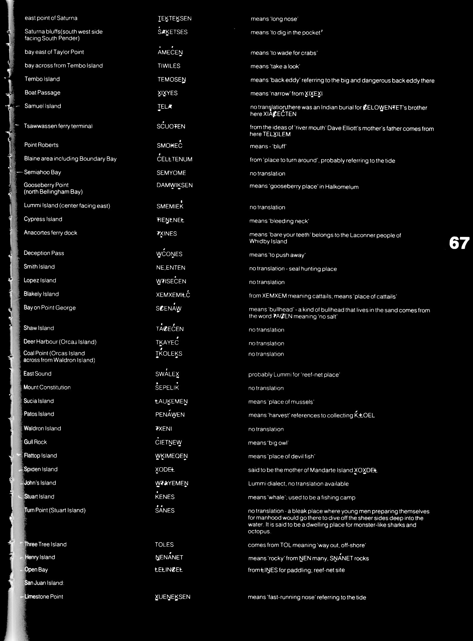
Page 68
| # | Name | PENÁĆ Says |
|---|---|---|
| 136 | WELÁLḴȽnorth end | comes from the term for singing of the LEHÁL game |
| 137 | ḰIḰELRoche Harbour | means ‘lime’ – referring to the lime deposits |
| 138 | SMÍYEWescott Bay | no translation – however some reference to ‘good’; location for duck-netting |
| 139 | PḰEILWEȽMitchell Bay | means ‘place of rotten wood’ from PḰȺ ‘rotten wood’ |
| 140 | WȺETEṈSmuggler’s Cove | means ‘place of ling cod’ – from ȺYET – ling cod |
| 141 | ŦIŦEḰcove between Smuggler’s and Andrews Bay | refers to ‘big head’ in Lummi; reef-net location |
| 142 | SȻEHENEAndrews Bay | no translation |
| 143 | W̱ṮEĆDeadman’s Bay | means ‘deep place’ |
| 144 | ṮIQENEṈCattle Point | means ‘place of peas’ referring to reef-net location of the Songhees |
| 145 | STOLȻEȽFriday Harbour | means ‘place way out’ from TOL |
| 146 | ĆḰALETENRocky Bay | comes from ĆEḰ, meaning ‘burn’ perhaps from a fire here |
| 147 | XELEXEṮEMGooch Islands group including Brethour, Domville and another | means ‘crossways’, because islands are across the current |
| 148 | PW̱ÁNForrest Island | means ‘blown’ |
| 149 | X̱OX̱DEȽMandarte Island | said to be the daughter of XODEȽ (Spiden Island) |
| 150 | SISȻENEMHalibut Island | from the idea of ‘someone sitting out just for the pleasure of the weather’. |
| 151 | SḰEŦÁMENSidney Spit, north end of Sidney Island | from ‘washed by the waves’ |
| 152 | W̱YOMEĆEṈsouthwest point on Sidney Island | means ‘to take caution’ from SYO meaning caution |
| 153 | ȾELXOLUwest side, beach across from James Island | means ‘place of defeat’; halibut fishing area |
| 154 | ȽELTOSJames Island | means ‘splashed in the face’ |
| 155 | KELJIEUEȽspit on the center east side of James Island | from KELEJ which means ‘shelter’ |
| 156 | ȽTÁĆSEṈnortheast corner of James Island | means ‘belonging to neck’ |
| 157 | BOḰEĆbluff south end of James Island | means ‘earth bluff’ |
| 158 | ĆTESUD’Arcy Island | means ‘just arrived’ |
| 159 | ĆTISULittle D’Arcy Island | from above |
Page 69
ACKNOWLEDGEMENTS
A number of people have contributed to the publication of this book and we appreciate the help of each of them.
Chris Doman teacher of the Career Graphics Program at Parkland School organized students:
- Len Collins – printing
- Emma Doman – camera work
- Kerry Kereluk – typesetting
- Wendy Laing – initial layout concept
- Hughes Partridge – reef-net fishery drawings
and help from other members of the graphics course.
Diana Henry transcribed and typed hours of taped lectures and interviews and typed the final manuscript.
The Split Salmon graphic used at the end of each chapter was designed especially for this book by Charles Elliott.
To them and everyone else who helped in anyway we are grateful.
Dave Elliott Sr.
Janet Poth
Back Cover
[Back cover: Falsified “signatures” made by HBC employees to “represent” South Island Indigenous leaders on the 1853 Douglas Treaty. At bottom right: Parkland Graphics logo and wordmark.]
HÍ,SW̱,ḴE SÍAM
(gratitude, honoured ones,
in SENĆOŦEN)
Comments
3 responses to “S1-1984: SENĆOŦEN Place Names in Saanich Territory*”
[…] People, a textbook written for schoolchildren that tells the history and culture of W̱SÁNEĆ. In the 1st edition, place names are listed in roughly geographical order in an appendix, with varyin…; in this 2nd edition, they are mapped, indexed, and in the middle of the […]
[…] S2-1995 is the reason Factso is here today. On December 15, 2023, I visited the UVic Library, having discovered that the nearest print copy of SISROFNC awaited me on the shelves there. Waiting to get my hands on it from the librarian I’d emailed, I went down another rabbit hole at the Law Library and gasped, picking up a signed 1984 first edition of Salt Water People by PENÁĆ Dave Elliott Sr. […]
[…] usual, the clue was in the title: Salt Water People, in its 1984 1st edition, includes a list of place names as an appendix with a free-flowing structure. I remember being […]